This listing of mines of the Cobalt-Gowganda area is a distillation of the mines listed in “Silver Cobalt Calcite Veins of Ontario, Ontario Department of Mines, by A.O. Sergiades, 1968. Changes that are known have been added, along with notes of particular interest to mineral collectors. The Lat/Long coordinates have been cross–referenced with current coordinates in the Government database in a best effort to be accurate. If you’d like to get a better visual idea of where many of these mines were, please visit the “Antique Map of the Cobalt Mining Camp” map located in the “Articles” section of this website.
I think that there are certainly errors in this material but, for the most part, there is good information on all of the bigger specimen producers and obscure mines.
Please note that most of these old mines are on private property and that permission needs to be obtained to visit any of them.
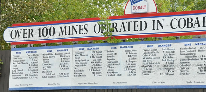
Cobalt Area
| Coleman Township | Tr. Oz Ag | Co -lbs |
| Alexandra Silver Mining Company Lat. 47º 22’ 28” Long. 79º 40’ 32” | 3,612,195 | 116,845 |
The Alexandra Silver mine was started in 1906 and became the Canadian Gold and Silver Mining Company in 1913. After two years of operation it was leased to various individuals, until 1962 when Silverfields Mining Corporation began to work it.
During the 1970s and 1980s, Teck Corporation purchased the Alexandra Property and operated it as the Silverfields mine. Teck mined and milled ore from other claims in the Cobalt Camp and operated them all as the Silverfields mine. The main Silverfields mine shaft and mill were near Cart Lake and served as a main source of mill feed. The Silverfields mill, however, also processed ore from dumps, small underground operations, pillar mining operations and as a custom milling operation, until 1983.
| Beaver Consolidated Mines Limited Lat. 47º 21’ 44” Long. 79º 38’ 26” | 7,127,858 | 139,868 |
The Beaver has long been a source of excellent high grade silver/cobalt specimens as well as leaf silver. In the late 1990s, cobalt ore was recovered from both the old Beaver and Timiskaming mines simultaneously from a shaft on the Beaver mine property and so newer dumps on the property are composed of a mix of material from both claims. Collectors may, thus, encounter specimens from the Beaver-Timiskaming mine.
| Brady Lake Property Lat. 47º 21’ 32” Long. 79º 38’ 54” | 2,250,136 | 190,812 |
Actually composed of three original claims; Lumsden, Rochester and Pan Silver. They were operated and separate properties until amalgamated under “Brady Lake Property” in 1947.
| Buffalo Mines Limited Lat. 47º 23’ 36” Long. 79º 41’ 28” | 14,154,558 | 152,406 |
Operated by a number of mining companies and leases, over the years before being acquired by Agnico Mines in 1957.
| Chambers Ferland Mining Company Limited Claim RL401, PCL 3&4 Lat. 47º 24’ 13” Long. 79º 40’ 41” | 2,297,000 | 25,415 |
| Claim RL402W, RL400E ½ Lat. 47º 23’ 53” Long. 79º 40’ 36” | 2,000,000 | 2,057,142 |
These claims were owned or leased by many companies but half of the production was accomplished by Silver Miller Mines Limited between 1954 and 1958.
| Christopher Silver Mines Limited Lat. 47º 21’ 22” Long 79º 38’ 55” | 4,100,000 | 2,143 |
Also known as Columbus Cobalt Silver Company, Cobalt Consolidated and was finally acquired by Agnico Mines Limited.
| City of Cobalt Mining Company Limited Lat. 47º 23’ 35” Long. 79º 41’ 25” | 14,000,000 | 25,022 |
This mine operated right under much of the central part of the town of Cobalt. The old head frame is still standing and currently houses a café. Also operated by Mining Corporation, Cobalt Properties Limited and eventually Agnico Mines Limited.
| Cobalt Badger Mining Limited Lat. 47º 21’ 52” Long. 79º 38’ 58” | 3,475 | 112 |
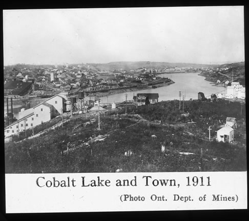
| Cobalt Lake Mining Company Limited Lat. 47º 23’ 29” Long. 79º 41’ 09” | 6,900,486 | 146,204 |
This property was made up of all of the land underneath Cobalt Lake and was operated by a number of companies over the years.
| Cobalt Lode Silver Mines Lat. 47º 21’ 24” Long. 79º 38’ 39” | 4,493,725 | 2,547,404 |
| Cobalt Silver Queen Limited Lat. 47º 23’ 19” Long. 79º 41’ 52” | 1,406,214 | 168,462 |
| Cobalt Townsite Mining Limited Lat. 47º 23’ 29” Long. 79º 41’ 27” | 32,150,746 | 4,120 |
| Cochrane Cobalt Mining Limited Lat. 47º 21’ 27” Long. 79º 38’ 24” | 33,280 | 2,705 |
| Colonial Mining Company Limited Lat. 47º 23’ 43” Long. 79º 39’ 41” | 1,211,956 | 3,675 |
| Coniagas Mines Limited Lat. 47º 23’ 51” Long. 79º 41’ 22” | 33,963,067 | 310,557 |
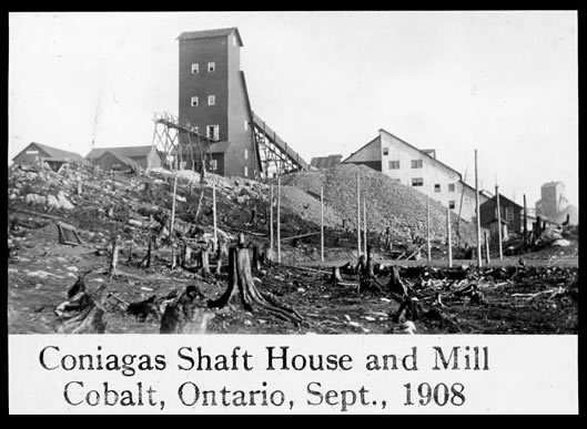
When I (DKJ) attended the Haileybury School of Mines, I visited the underground workings of the Coniagas (Cobalt-Nickel-Silver-Arsenic) mine a couple of times to learn how to do geological mapping underground. I recall that the mine manager showed us big chunks of high-grade silver consisting of masses of black, heavy silver arsenide and sulfide mineralization that they were recovering from “pillar-robbing” extraction work.
This claim was operated by W. Trethewey for two years before it was acquired by Coniagas Mines Limited It was bought and sold by a number of companies over the years.
| Conisil Mines Limited Lat. 47º 22’ 12” Long. 79º 39’ 40” | 100,000 | |
| Consolidated Silver Banner Property Lat. 47º 23’ 19” Long. 79º 41’ 52” | 41,701 | |
| Cross Lake O’Brien Property Lat. 47º 23’ 29” Long. 79º 38’ 44” | 2,846,103 | 97,211 |
This property was operated for many years by M.J. O’Brien Limited and then by Deer Horn Mines Limited Specimens may also be referred to as coming from the Deer Horn mine.
| Crown Reserve Mining Limited Lat. 47º 22’ 33” Long. 79º 39’ 33” | 20,325,302 | 33,713 |
This claim consisted of all of the land under Kerr Lake. Spectacular silver specimens have been recovered by mineral collectors in the area of the mine workings.
| Drummond Mines Limited Lat. 47º 22’ 36” Long. 79º 39’ 11” | 3,887,585 | 246,029 |
The Drummond mine was owned by Henry Drummond, a famous Canadian poet. He immigrated from Ireland, attended McGill University and became a medical doctor. He became famous writing poems about the French Canadian Habitant, the rural people of Quebec. He learned about the silver strikes at Long Lake from an assayer at McGill University and headed to Cobalt. He staked a claim just north of Kerr Lake, and operated and managed the Drummond mine until his death in April of 1907. The Drummond Cairn was originally the chimney from his home, beside the mine. It was designated an historical place in the 1930s and more recently was moved into Cobalt from the mine site, near Kerr Lake.
| Farah Mining Company Limited Lat. 47º 23’ 06” Long. 79º 39’ 20” | 8,952 | |
| Foster Cobalt Mining Company Limited Lat. 47º 22’ 22” Long. 79º 39’ 57” | 1,159,390 | 457,574 |
| Hargrave Silver Mines Lat. 47º 22’ 18” Long. 79º 39’ 14” | 506,927 | 6,424 |
| Hiho Mine See Kerr Lake Mining Company | ||
| Hudson Bay Mine Lat. 47º 24’ 15” Long. 79º 41’ 12” | 6,452,266 | 185,739 |
| Juno Metals Corp. Lat. 47º 22’ 59” Long. 79º 39’ 40” | 46,391 | |
| Kerr Lake Mining Company Lat. 47º 22‘ 31” Long. 79º 39’ 29” | 28,502,037 | 650,679 |
This property was worked by a number of companies over the years but famously by the Hiho Silver Mines Limited. Specimens may be referred to as coming from the Hiho Mine.
| King Edward Mining Company Lat. 47º 23’ 33” Long. 79º 38’ 20” | 1,294,233 | 650,679 |
Was also referred to as the Watts Mine in the earliest days of Cobalt.
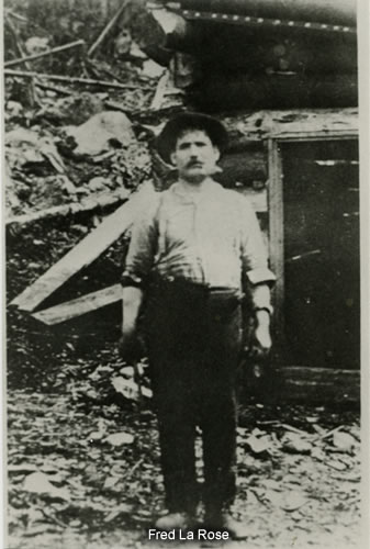
| La Rose Mines Limited Lat. 47º 24’ 00” Long. 79º 40’ 33” | 26,283,372 | 1,010,720 |
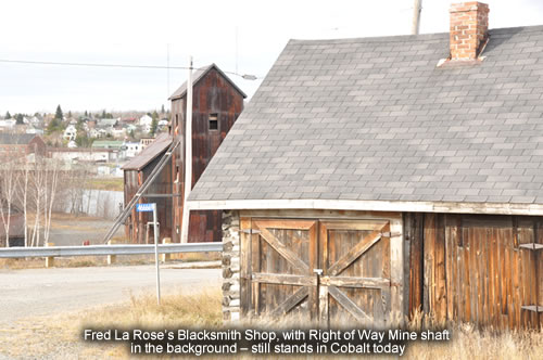
Named for the railroad blacksmith, Fred La Rose, who is credited with finding the first silver at Cobalt. Fred’s original blacksmith shop still stands near the mine site. Since the veins were exposed on the cliff faces at the north end of Cobalt, they are prominent to this day.
| Lawson Mine Lat. 47º 22’ 26” Long. 79º 39’ 41” | 4,213,513 |
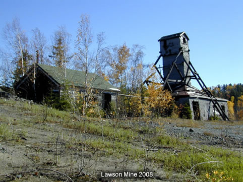
One of the veins mined on this property was the famous “Silver Sidewalk”, so called because the surface expression of the vein was almost 1000 feet long and appeared to be a width of about 6-8 inches of largely solid silver.
| Little Nipissing Claim JB2 Lat. 47º 23’ 08” Long. 79º 41’ 44” | 82,000 | |
| Lumsden Claim (See Brady Lake Property) | ||
| Mayfair Mines Limited Lat. 47º 20’ 44” Long. 79º 38’ 36” | 26,240 | |
| McKinley-Darragh Savage Mines Lat. 47º 23’ 19” Long. 79º 41’ 28” | 17,300,000 | 465,582 |
Named for the two men who staked the first claim in the Cobalt Mining Camp. Usually referred to as the McKinley-Darragh Mine.
| Mensilvo Mines Limited Lat. 47º 22’ 29” Long. 79º 40’ 55” | 374,824 | 149,643 |
| Nancy-Helen Mines Limited Lat. 47º 23’ 40” Long. 79º 41’ 26” | 91,770 | |
| Nerlip Mines Limited Lat. 47º 23’ 56” Long. 79º 39’ 09” | 911 | 2,949 |
| New Bailey Mines Limited Lat. 47º 22’ 20” Long. 79º 40’ 14” | 3,131,352 | 76,849 |
Also, popularly known as the “Glen Lake Mine” today. Excellent high grade silver-cobalt ore can still be found in the old dumps at this property.
Nipissing Mines Limited
| Claim 404 Lat. 47º 23’ 33” Long. 79º 40’ 53” | 91,796,735 | 5,641,757 |
| Claim 406 Lat. 47º 22’ 49” Long. 79º 41’ 17” | 1,236,879 | 74,036 |
| Claim 407 Lat. 47º 22’ 51” Long. 79º 40’ 28” | 1,843,633 | 157,738 |
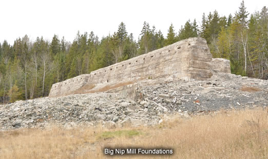
Most mines of the Cobalt area were each located on a single claim or portion of a claim. The Nipissing mine property however was originally staked as four claims, on some of the richest ground in the Cobalt Camp. This explains the extensive workings and large mill site of “the Big Nip”. The many mine dumps have been the source of some nice high grade silver and silver leaf over the years. As well, because of the concentration of veins on the property, very good “Glacial Float” has been located by collectors with metal detectors. These claims were eventually all acquired by Agnico mines and operated along with other claims from the 1960s until the 1980s.
| Nova Scotia Silver Mining Company Lat. 47º 23’ 14” Long. 79º 39’ 44” | 1,082,774 | 114,301 |
| M.J. O’Brien Lat. 47º 23’ 57” Long. 79º 40’ 06” | 43,739,820 | 3,124,504 |
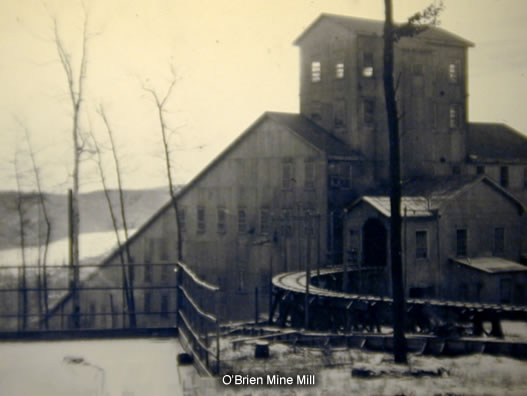
The O’Brien mine yielded some amazing high grade in its heyday. Some of this material escaped the miners and can still be found to this day on mine dumps. As well, the O’Brien had zones that produced good crystals of acanthite pseudomorphs after argentite, proustite and other secondary silver minerals. If collectors encounter well-crystallized specimens of such minerals from this (or any others) mine, they are no doubt very old specimens from the actual mining operations.
| Pan Silver Claim (see Brady Lake Property) | ||
| Penn Canadian Mines Limited Lat. 47º 22’ 32” Long. 79º 40’ 16” | 4,418,802 | 190,821 |
| Peterson Lake Silver-Cobalt Mining Company Limited (Peterson Lake) Lat. 47º 23’ 16” Long. 79º 40’ 33” | 918,076 | 27,328 |
| Peterson Lake Silver-Cobalt Mining Company Limited (Cart Lake) Lat. 47º 22’ 52” Long. 79º 41’ 02” | 5,711,490 | 7,787 |
| Princess Claim Lat. 47º 23’ 16” Long. 79º 41’ 44” | 3,713,806 | |
| Red Jacket Property Lat. 47º 22’ 36” Long. 79º 42’ 20” | 3 | 355 |
| Reinhardt Cross Lake Group Lat. 47º 23’ 26” Long. 79º 38’ 44” | 278,631 | 2,535 |
| Right of Way Mines Limited North Mine Lat. 47º 23’ 52” Long. 79º 40’ 43” | 2,969,195 | 41,811 |
| South Mine Lat. 47º 23’ 22” Long. 79º 41’ 35” |
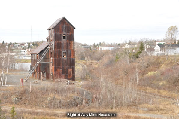
The Right of Way mine was one of the most prominent mines in Cobalt since it is right beside the railway, in the middle of town. The head frame (North Mine) still stands, today.
| Rochester Claim (see Brady Lake Property) | ||
| Savage Mine (McKinley Darragh) Lat. 47º 23’ 19” Long. 79º 41’ 28” | 4,500,000 | 465,582 |
This mine and the McKinley Darragh mine were both operated by the same company, McKinley Darragh-Savage Mines Limited, during the hey-days of Cobalt from 1903 onwards.
| Silver Cliff Mining Company Limited Lat. 47º 23’ 40” Long. 79º 39’ 20” | 535,246 | 9,323 |
| Silver Cross Cobalt Mining Company Ltd Lat. 47º 22’ 54” Long. 79º 38’ 45” | 3,091 | |
| Silverfields Mine See Alexandra Silver Mining Company | ||
| Silver Leaf Mining Company Ltd Lat. 47º 22’ 33” Long. 79º 39’ 38” | 495,443 | 1,208 |
| Silver Miller Mines Ltd. Lat. 47º 23’ 53” Long. 79º 40’ 36” | 2,030,000 |
This company operated the Brady Lake Property for a number of years. Some specimens may be attributed to Silver Miller mine.
| Smith Cobalt Mines Limited Lat. 47º 23’ 26” Long. 79º 38’ 19” | 456 | |
| Timiskaming Mining Company Limited Lat. 47º 21’ 40” Long. 79º 38’ 27” | 12,118,796 | 202,869 |
This mine has been a very good producer of high grade silver, using metal detectors, over the years.
See Beaver mine for additional info on the Timiskaming.
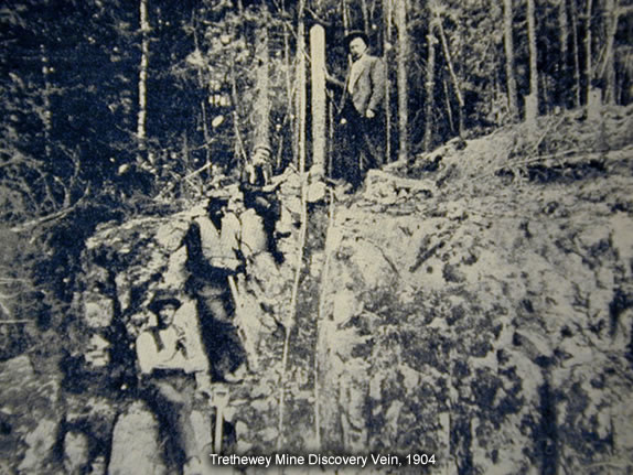
| Trethewey Silver Cobalt Mines Limited Lat. 47º 24’ 01” Long. 79º 41’ 09” | 7,256,470 | 216,392 |
| University Mines Limited Lat. 47º 22’ 12” Long. 79º 40’ 15” | 790,000 | 82,681 |
| Violet Mining Company Limited Lat. 47º 23’ 52” Long. 79º 39’ 42” | 897,291 |
| Cleopatra Mining Company Limited Lat. 47º 22’ 10” Long. 79º 40’ 29” | 2,160,356 | 136,069 |
Good high grade has been found in recent years in waste dumps around this old mine.
| Provincial Mine Lat. 47º 22’ 36” Long. 79º 41’ 11” | 286,897 | 54,522 |
Interestingly this claim was put aside by the government of Ontario to be mined by a government-controlled company “for the people” something unusual for the time. The mine was opened but operated for only a short time before the ore ran out. It was a money losing venture. The government turned it over to a private company who also failed to make it go.
| Waldman Silver Mines Limited Lat. 47º 22’ 17” Long. 79º 41’ 08” | 33,525 | 2,068 |
| Wyandoh Silver Mines Limited Lat. 47º 22’ 16” Long. 79º 41’ 03” | 33,699 | 1,235 |
| Agaunico and Reuthel mine Lat. 47º 25’ 08” Long. 79º 36’ 17” | 980,000 | 4,353,909 |
The “Agaunico” in this mine's name supposedly stands for Ag-Silver, Au –gold, Ni –nickel and Co –cobalt. The gold may have been wishful thinking. Purportedly, some gold was found at this mine.
| Cobalt Contact mine Lat. 47º 24’ 55” Long. 79º 36’ 59” | 26,000 | 31,028 |
| Dotsee mine Lat. 47º 25’ 41” Long. 79º 45’ 16” | 125 | 8,007 |
| Genesee Mining Company Lat. 47º 24’ 30” Long. 79º 40’ 21” | 69,404 | 12,079 |
| Green-Meehan and Red Rock mine Lat. 47º 24’ 54” Long. 79º 37’ 10” | 498,000 | 27,024 |
| Harrison-Hibbert and Ruby mine Lat. 47º 24’ 53” Long. 79º 37’ 32” | 876,500 | 214,792 |
| North Cobalt and Hunter mine Lat. 47º 25’ 16” Long. 79º 37’ 30” | 1,453 |
| Casey Cobalt-Silver Mines Limited Lat. 47º 34’ 53” Long. 79º 34’ 48” | 10,094,801 | 384,157 |
Also popularly referred to as the Langis mine, after the Langis Silver and Cobalt Mining Company, a company which operated it for a while during the 1960s. The Langis has been the source of some of the best dendritic silver, high-grade ore. Specimens often consist of chunks of ore, sawn to reveal intricate “herringbone” patterns of silver crystals, usually coated with arsenide minerals in carbonate vein material. Sometimes the carbonates can be leached away with acid to reveal excellent herringbone crystal structures. The Langis mine is located on an isolated patch of Cobalt sediments and Nipissing diabase about 12 miles north of Cobalt, at the north end of Lake Temiskaming, near New Liskeard.
| Harmak Mining Company Lat. 47º 34’ 34” Long. 79º 35’ 01” | 4,625 | 12,937 |
| Lang Caswell Mine Lat. 47º 34’ 34” Long. 79º 35’ 01” | 1,503 | 4,932 |
Elk Lake Area
| Roy Silver Mines Limited Lat. 47º 46’ 59” Long. 80º 27’ 46” | 1,888 |
| Ethel Copper Mines Limited Lat. 47º 44’ 53” Long. 80º 16’ 29” | 6,061 | |
| Moose Horn Mines Limited Lat. 47º 44’ 17” Long. 80º 18’ 46” |
The Moose Horn mine was not a prolific silver producer. Only a few tons of silver ore, rich in nickeline were ever shipped. However, the Moose Horn mine was the source of Temiskamite, Ni11As8, which was proposed as a new mineral and was, in fact, a new mineral. Unfortunately, German scientists had characterized maucherite just prior to the characterization of Temiskamite and thus the name maucherite took priority. Temiskamite was subsequently discredited.
| Mother-Lode Mining Company Limited Lat. 47º 44’ 39” Long. 80º 21’ 29” | 1,581 |
| Mapes-Johnston Mining Company Limited Lat. 47º 44’ 16” Long. 80º 26’ 19” | 1,000 | 870 |
| Otisse Mining Company Lat. 47º 43’ 16” Long. 80º 26’ 32” | 2,380 | 26 |
| Shane-Darragh Claim W.D. 904 Lat. 47º 43’ 15” Long. 80º 25’ 20” | 63,417 | 1,214 |
| Lucky Godfrey Silver mines Lat. 47º 39’ 46” Long. 80º 16’ 54” | 9,835 | 593 |
| Cane Silver Mines Limited Lat. 47º 36’ 11” Long. 80º 01’ 29” | 3,100 |
| White Reserve Mines Limited Lat. 47º 26’ 22” Long. 80º 16’ 47” | 19,775 | 452 |
Gowganda Area
The Capitol mine has been a favorite collecting locality for collectors with metal detectors and has produced many fine specimens of dendritic silver ore over the years. Much bulldozer work was done on the dumps and grounds of this property in 2012, which revealed large amounts of high-grade silver ore, much of which has been recovered by collectors with metal detectors. Excellent potential there.
| Castle-Trethewey mine Lat. 47º 40’ 45” Long. 80º 44’ 27” | 9,410,095 | 376,392 |
The “Castle mine”, as it is usually known, still yields nice high-grade and crystallized silver specimens today.
| Miller Lake Everett mine Lat. 47º 40’ 41” Long. 80º 44’ 38” | 3,461 | |
| Millerett mine Lat. 47º 40’ 16” Long. 80º 44’ 34” | 611,822 | 5,004 |
| Bishop, Caleta & Keora mine Lat. 47º 39’ 22” Long. 80º 39’ 28” | 42,400 |
| Hudson Bay Silver Mines Limited Lat. 47º 30’ 47” Long. 80º 48’ 17” | 80,186 | 567 |
This mine, also known as the Rustex mine and Rusty Lake mine, has produced superb specimens of skutterudite. The skutterudite occurs as crystals in calcite veins, with silver and other arsenides. The calcite can be removed with acid to reveal clusters of sharp, lustrous skutterudite with crystals to 0.5 inches in size.
| Bartlett mine Lat. 47º 35’ 49” Long. 80º 48’ 46” | 20,219 | 18 |
| Mann/ Boyd Gordon mine Lat. 47º 37’ 16” Long. 80º 48’ 57” | 123,620 |
Specimens of branching silver crystals in oxidized arsenides have been found over the years at this mine. These specimens are usually said to be from the Manridge mine after Manridge Mines Limited, a company that operated it as well as the Bartlett, Boyd Gordon mines, Reeve-Dobie, South Bay and Welch mines.
| Reeve-Dobie mine Lat. 47º 36’ 11” Long. 80º 48’ 50” | 88,584 | |
| South Bay mine Lat. 47º 35’ 31” Long. 80º 48’ 10” | 1,500 | |
| Welch mine Lat. 47º 35’ 57” Long. 80º 48’ 57” | 1,000 |
| Miller Lake O’Brien mine Lat. 47º 39’ 58” Long. 80º 44’ 01” | 43,181,431 | 787,350 |
This mine has been a source of rich high grade, found with metal detectors.
| Morrisson mine Lat. 47º 39’ 10” Long. 80º 42’ 54” | 719,522 | 22,064 |
| Walsh mine Lat. 47º 39’ 30” Long. 80º 43’ 39” | 453,424 | 3,563 |
Silver Centre Area
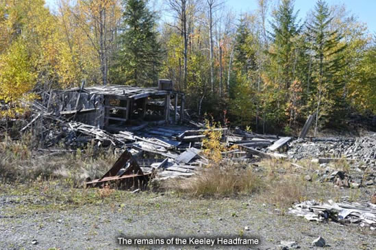
The “Woods Vein” of this rich silver producer was also a prolific specimen producer. Most of the mines in the Cobalt area did not contain many open vugs where proustite, wire silver and other rare silver minerals could form. According to Sergiades, 1968, pg. 428, “Pre-glacial weathering on part of the Woods vein extends to 480’ depth; ore deposition in consequence is partly secondary and the vein vuggy.” The collection of the Royal Ontario Museum has excellent specimens of wire silver from the Keeley and Frontier mine as well as superb proustite specimens with well formed crystals to 0.75 inches.
This was a rich mine and superb examples of high-grade ore have been found in the waste dumps with metal detectors.
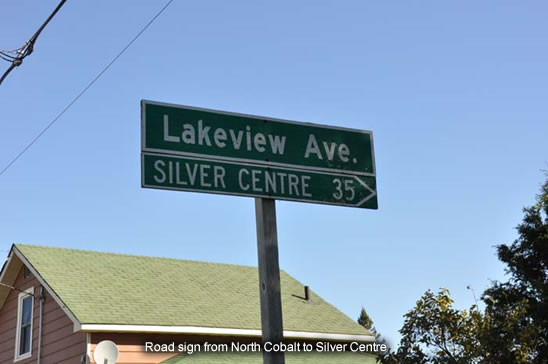
Note about Silver Centre: When the South Lorrain Silver Mining area was booming starting in 1907, a town called Silver Centre was established. It was a proper town, with a well laid out town site and with great hopes for the future. Unfortunately it did not last. It is considered the area’s “ghost town” and remnants of Silver Centre may still be encountered in what is now wilderness, again. It is mentioned here since collectors may very well run into this name on labels or in writings on the Cobalt area. Interestingly, there is still a road sign in North Cobalt that points people in the right direction and distance for Silver Centre.